Unlock market opportunities, analyze spatial data with ease, and grow your business faster and smarter.
GeoTency is a powerful, intuitive geospatial analytics platform designed to help businesses make smarter, location-driven decisions. By combining the latest in Geographic Information System (GIS) technology with user-friendly tools, GeoTency turns complex spatial data into clear, actionable insights.
Where Data Meets Location. Your Business Finds Direction.
Unlock market opportunities, analyze spatial data with ease, and grow your business faster and smarter.
GeoTency helps businesses make smarter location decisions using Location Intelligence technology. With key features such as Site Analysis, Exploring Potential Areas, Demographic Insights, Trade Area, Geohash Explorer, and POI Explorer, GeoTency enables businesses to evaluate, compare, and justify area that best support business development.
With GeoTency, building your business expansion strategy becomes faster, more precise, and data-driven. It’s the perfect starting point to explore new regions, test expansion ideas, or simply see if a spot is worth the next step. No guesswork — just clear, credible insight.
INDUSTRIES & SERVICES
GeoTency provides smart location analytics services using spatial data to help businesses find the right place to grow. From market potential mapping to custom spatial reports, we turn complex geodata into clear, actionable insights — all powered by geohash, hexagon analysis, and API-ready solutions.
WHAT THEY SAY
Hear from our clients and partners who have experienced the value of GeoTency firsthand. From smarter location decisions to faster business insights, their stories reflect how geospatial intelligence is transforming the way they work.
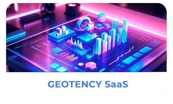
GEOTENCY SaaS
A smarter way to make location-driven decisions.
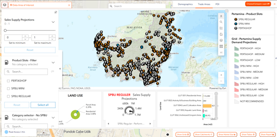
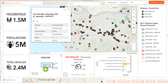
GeoTency SaaS is a smart analytical platform that combines geospatial, demographic, and market trend data into one user-friendly visual system. Designed to help businesses understand market dynamics in real-time, GeoTency SaaS delivers actionable insights for expansion planning, site selection, and potential area validation.
With interactive maps and precise intelligence, it helps you navigate Indonesia’s diverse market landscape from dense urban zones to emerging areas — efficiently and accurately. More than just an analysis tool, GeoTency SaaS is your partner in building smarter, data-driven, and sustainable growth.
What Will You Get With GeoTency SaaS?
Unlock the full potential of location data with these powerful benefits:
Area Profiling : Process of gathering and analyzing data about a specific geographic location to understand its characteristics, such as demographics, infrastructure, economy, social conditions, and potential risks or opportunities. This helps in planning, decision-making, and targeted interventions.
Data Report & Visualization : The process of presenting data in a structured report combined with visual elements like charts, graphs, and maps. It helps users easily understand trends, patterns, and insights to support better decision-making.
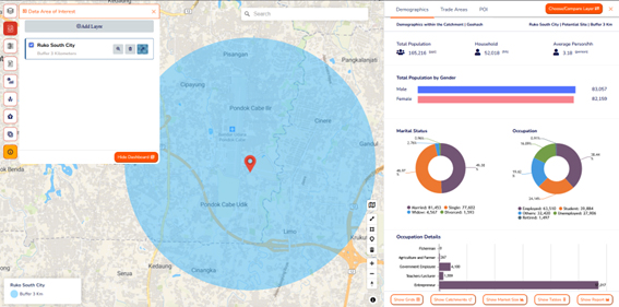
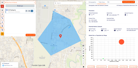
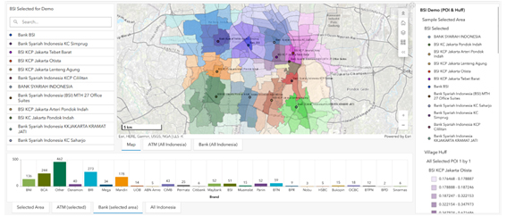
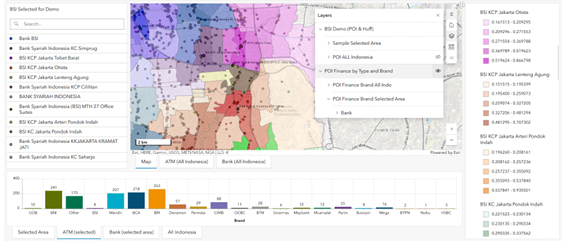
Spatial Map Toolkit : A set of tools designed to visualize and analyze location-based data through interactive maps. It helps businesses make informed planning decisions—such as selecting the right business location, defining trade areas, entering new markets, and understanding the surrounding environment of a specific site. The final output supports strategic decisions with clear geographic insights.
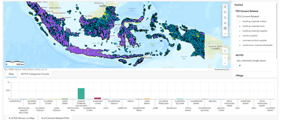
Data Acquisition & Integration : It involves collecting and combining data from multiple sources (including your data) to create a single, integrated dataset. This includes Point of Interest (POI) Classification, which categorizes important locations based on their attributes, and Spatial Data Services, which provide geographic data processing and analysis. Together, these processes produce accurate and comprehensive spatial insights.
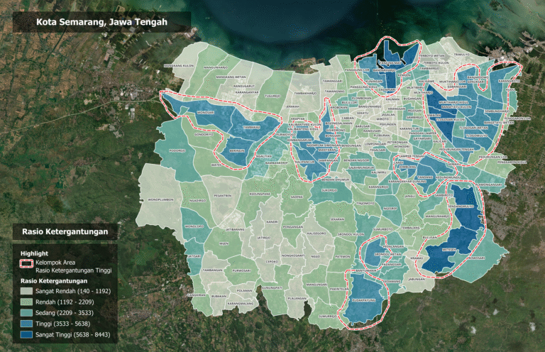
This segmentation approach uses the dependency ratio of the population on a specific product or service.
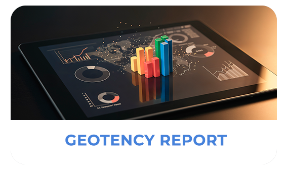
GEOTENCY REPORT
The GeoTency Report is a comprehensive location analysis designed to support both SMEs and large-scale businesses in making confident, data-driven decisions. Built on geospatial data, the report combines Trade Area analysis with detailed demographic insights, socio-economic segmentation, and Points of Interest (POI) mapping — all tailored to your specific business needs.
Whether you’re planning to open a new outlet, assess site performance, or expand your market coverage, GeoTency equips you with a full picture of a location’s true potential. From neighborhood profiles to purchasing power and market behavior, this single report brings together all the essential insights needed to reduce guesswork and improve location strategies.
1. GeoTency Trade Area & Market Report
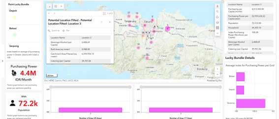
This Report is a comprehensive location insight designed to help businesses understand the true potential of an area. It doesn’t just show how far a location can reach in terms of distance or travel time — it also reveals who lives within that area. GeoTency Trade Area & Market Report delivers comprehensive location-based market insights to help businesses evaluate the potential of a specific area before making strategic decisions.
In the modern geospatial analysis landscape, coverage and accessibility are typically measured using two methodologies: buffer analysis and isochrone analysis.
Buffer analysis is a geospatial methodology that creates polygons around one or more objects (points, lines, or areas) at a uniform and specified distance. The result of this analysis is a zone with a fixed radius, which visually represents a pure spatial extent.
Fundamentally different from buffers, isochrone maps define an area based on travel time to or from a specific location. This analysis no longer uses distance as the primary metric but rather the time it takes to access existing transportation networks (e.g., roads, pedestrian paths, or public transportation routes) over a specified period of time.
With just one report, you can assess whether a location is suitable for expansion, a new outlet, or targeted marketing strategies. Inside the report, you’ll find valuable demographic data such as age groups, gender, occupation, and socioeconomic levels, along with insights into local purchasing power and estimated sales potential. This gives you a clear picture of your potential market.
2. Mitigation Report
A geospatial-based mitigation report is a report that helps us understand and reduce the risk of disasters or losses in a specific area by analyzing location data. With the help of digital maps, satellite imagery, and other mapping technologies, you can identify vulnerable areas or locations, such as those prone to flooding, landslides, or fires.
This report is highly valuable for local governments, developers, or companies looking to make smarter and safer decisions — from spatial planning and infrastructure development to environmental management.
Why Is It Important?
✅ Reduces the risk of future losses ✅ Supports location-based decision-making ✅ Enables safer and more sustainable planning ✅ Enhances disaster preparedness
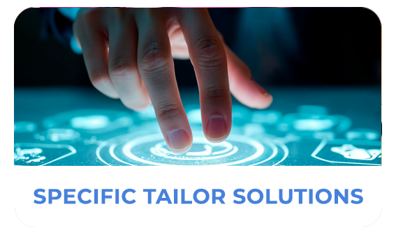
SPECIFIC TAILOR SOLUTION
Custom Solutions, Tailored to Your Business Goals
At GeoTency, we understand that every business has unique challenges. That’s why we offer customized solutions—designed to meet your specific operational and strategic needs.
We provide area recommendations based on location potential, conduct network analysis to evaluate the performance and reach of your current business locations, and build a consolidation strategy to help you streamline your network of locations for greater efficiency and impact. With data-driven geospatial insights, we empower your business to grow smarter—making every decision meaningful.
1. Potential Area Recommendation
GeoTency potential area recommendations help your business identify the best locations to grow — accurately and efficiently. Using location data and geospatial analysis, we pinpoint areas with the highest market potential, whether for new store openings, branch expansion, or more targeted marketing strategies. This analysis takes into account key factors such as population size and demographics, accessibility, local economic activity, and competition levels around the area. As a result, you can make smarter strategic decisions based on real data.
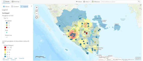
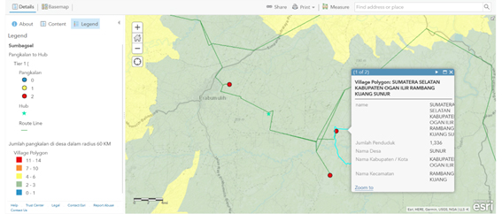
2. GeoTency Routing Analysis
In today’s fast-paced business world, time and cost efficiency are everything. With location analytics, you can intelligently find the best routes — whether for delivery, field team scheduling, or distribution planning. This technology uses spatial data and road networks to analyze the fastest and most efficient paths, taking into account travel time, traffic conditions, and even multi-stop routes. The result? Lower operational costs, happier customers, and more productive field teams. It’s time to move your business forward with data-driven, smarter routing solutions.
This analysis is essential for efficient expansion planning, avoiding cannibalization, and optimizing your presence in a competitive market.
3. GeoTency Consolidation Strategy
GeoTency’s Consolidation Strategy helps businesses assess and streamline their existing location network. Through location performance analysis, overlapping trade area detection, and nearby market potential evaluation, we help identify which outlets to keep, merge, or relocate.
This strategy is perfect for companies seeking to improve operational efficiency, boost profitability, and maintain an optimized market presence.
4. Geospatial Data Analysis
Geospatial data analysis is an intelligent process that transforms location data into easy-to-understand visual insights. The process begins with the search and collection of relevant data—such as population data, infrastructure, road networks, and satellite imagery. The data is then cleaned, processed, and analyzed using spatial technologies and methods, presented in clear, intuitive, and easy-to-use interactive maps or spatial visualizations. You can discover patterns, trends, and hidden potential within an area, which is invaluable for strategic decision-making such as business location, risk management, infrastructure planning, and more.
CONSULTANT SERVICES
Locator Logic Solutions Consultant Services provide strategic support for businesses looking to deeply understand their market using spatial data. We assist in expansion planning, location analysis, and market potential evaluation with accurate, location-based intelligence.
From retail and F&B to property, our team is here to guide your business toward smarter, lower-risk decisions based on solid data.
PROFESSIONAL PLACEMENT
The Professional Placement service provided by Locator Logic Solutions focuses on the efficient placement of professional human resources (HR), tailored to the specific needs of your company. This service encompasses the recruitment, selection, and placement process of skilled personnel in their respective fields—whether for temporary positions, long-term roles, or special projects. With a flexible, needs-based approach, Locator Logic Solutions delivers ready-to-deploy talent who can quickly adapt to your company’s culture and work systems.
This service also functions as a vital operational support, particularly in the retail, GIS (Geographic Information System), digital platform, information technology, and field operations sectors. By utilizing Locator Logic Solutions’ Professional Placement service, your company can concentrate more on core business strategies without the burden of directly managing recruitment and HR processes. This not only improves operational efficiency but also provides cost and resource management advantages.
The professional placements we provide include:
Retail Expert Proffesional Placement Category:
Retail GIS Analyst
Location Intelligence Specialist (Retail Sector)
Retail Expansion Planner (with GIS Focus)
Spatial Data Coordinator – Retail Operations
Market Mapping Specialist (Retail Intelligence)
Retail Site Selection Analyst
GeoMarketing Analyst
GIS Professional Placement Category:
GIS Analyst / GIS Specialist
Remote Sensing Analyst
Cartographer / Digital Map Designer
GIS Data Manager / Spatial Data Coordinator
GIS Developer (Mid-level)
Urban Planning GIS Analyst
Field GIS Coordinator
Geospatial Intelligence Analyst (GeoINT)
IT Professional Placement Category:
Software & Application Development
Software Engineer (Mid-level)
Backend Developer
Frontend Developer
Full-Stack Developer
Mobile App Developer (Android/iOS)
QA Engineer / Software Tester
DevOps Engineer
IT Infrastructure & Support
System Administrator
Network Engineer
IT Support Specialist (Tier 2/3)
Cloud Engineer
IT Security Analyst
Data & Analytics
Data Analyst
Database Administrator (DBA)
Business Intelligence (BI) Developer
ETL Developer
Project & Product
IT Project Coordinator / Associate Project Manager